by Katja Mayer and Carsten Horn
In our blogpost we delve into the complexities of the in/visibilities of inequalities in the global digital transformation. In particular, we explore the theme inspired by Noopur Raval’s thought-provoking commentary on the notion of “ghost work.” Raval’s commentary challenges the discourse surrounding the invisibility of workers from the Global South, despite the good intentions of global pro-worker reforms. This raises important questions about the conditions and meanings of visibility and how they shape our understanding of social change. We report how we examined and discussed how to make the socio-technical complexity of infrastructures visible, and the challenges of translation of visibility into social change.
The DigiGov Winter School 2023, themed “Digital Practices and Global Inequalities,” brought together 29 participants with a number of experts from diverse disciplinary and cultural backgrounds to explore the complex relationship between digital technologies and social inequality. Big data and artificial intelligence have further exacerbated the existing (digital) divide between geopolitical regions, as well as within societies, with marginalised communities often lacking access to the necessary digital infrastructure and skills to engage with and benefit from these technologies, or being exploited by the extractive logics of resource hungry digital technologies. This blog post reports on the insights gained from Day 2 of the Winter School. Through two lectures and a mapping workshop, the participants examined how digital technologies can both perpetuate and alleviate global digital inequalities and discussed how to work towards a more inclusive and equitable future.
The second day of the Digigov Winter School was dedicated to the topic of in/visibilities of inequalities in the global digital transformation. This theme was inspired by Noopur Raval’s fabulous and timely comment problematising the notion of “ghost work” (Gray & Suri, 2019) that is dominated by the Global North – despite the good intention to pave the way for global pro-worker reforms. Raval challenges the public and academic discourse “ghosting” those workers and pushes us to ask: Who are these workers invisible to? And why has “visibility” historically not translated to social change? (Raval, 2021). These questions attune us to the conditions and meanings of visibility: how do we construct and constitute visibility at all? What infrastructures are necessary for this and how do they shape what we can perceive? Where can we look at all, and what do we gain from these perspectives?
As Monika Halkort demonstrated in her talk, visibility and invisibility is a matter of selective perspective. Remote sensing devices – such as those put in place for the monitoring of marine environments – selectively construct and reorganise their objects of sensing through regimes of visibility and attention. Whereas there is an abundance of information available on dying species in marine habitats in the Mediterranean Sea, the exact number of irregular migrant deaths at sea is difficult to determine because data are not systematically collected.
Together with Felix Stalder and Vladan Joler – first in a lecture and then in a workshop – we ventured a look at the diverse socio-technical infrastructures that not only format those regimes of in/visibilities but also make our knowledge production and its commodification possible. In their work which straddles the boundaries of academia and arts they propose maps (such as the one below) to make these infrastructures legible in their complexity and heterogeneity.
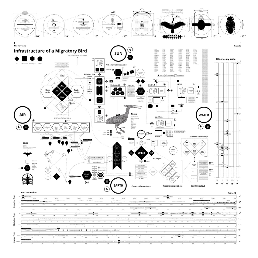
Their Infrastructure of a Migratory Bird project maps the infrastructures necessary for the rewilding of the northern bald ibis, a bird that went extinct in Europe 400 years ago. The project is one of the most ambitious conservation projects underway, aiming to re-introduce the bird to Europe. With the help of the above map, we see the relationships between social, technological, informational, and ecological elements that make up the ecosystem in which the bird is becoming wild again. The map also provides spatial, monetary, and temporal dimensions for these elements. However, creating, reading, and using such a map poses significant challenges to visualisation practices, especially in dealing with incompleteness and perspective. (Listen to the audio guides here!)
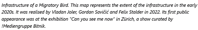
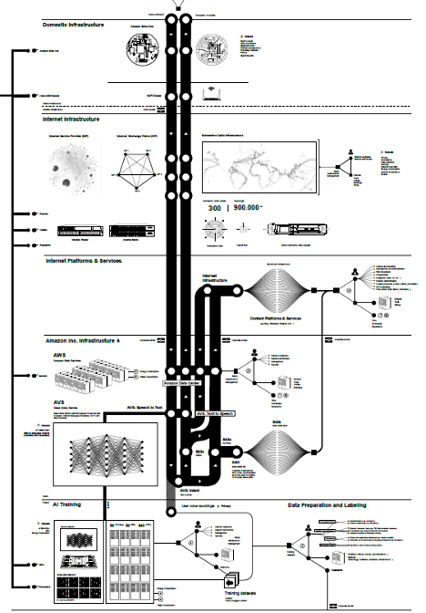
These challenges also became evident when we explored another marvellous map, that of the Anatomy of an AI System by Vladan Joler, based on his cooperation with Kate Crawford. The new manifestations of machine learning and artificial intelligence rely on various forms of planetary exploitation of labour and resources that often go unnoticed. Joler provides a detailed infographic and essay mapping the different types of infrastructures and resources that make up the global system behind Amazon’s “Echo” device. The map illustrates the various processes and resources involved in making the “Echo” device work, from rare earth extraction to data flows. Joler’s work makes it possible to critically examine the interconnected but diverse infrastructures necessary for smart devices to function. In the afternoon workshop we explored this map in small groups, trying to find our own pathways and navigation around specific topics driven by students’ concerns.
In the following you will find a short interview with workshop participant Carsten Horn. Carsten reports how he experienced the group exercise and discusses mapping as a method or tool of(critical) research into digital infrastructures. He points out possible shortcomings or blind spots of mapping as well as potential contributions of this technique to intervention into the regimes of in/visibility and the injustices that global digital infrastructures create and maintain.
Carsten, how did you experience this exercise (Anatomy of AI map)?
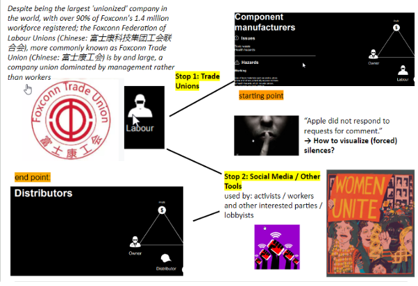
In the literature on digital infrastructures, scholars have emphasised the gap that exists between metaphors of “the cloud” and the materiality – and material impacts! – of these infrastructures (e.g. Holt & Vonderau, 2015). From this perspective, I thought that the map is a powerful tool for grounding such metaphors. It makes us aware of how our digital practices mobilise a vast, global network including its material consequences. In the session itself, it was a great privilege to have Vladan as one of the creators of the map guide us through the map and then, after the group work, to discuss our findings with him. The group exercise for me was a very stimulating way to use the map as a tool for (desk) research. Especially the interdisciplinarity of our group made the discussions very vivid and I thought identifying the worker protests at Foxconn as a story of failed (yellow) unionisation that emerged from them was really interesting.
Which part of the map immediately caught your attention and why?
When first looking at the map and reading the accompanying description the lines and flows caught my attention – more so than any individual node. Starting from a mundane, seemingly innocent action such as giving a command to your digital assistant you find yourself drawn out to different locations, temporalities, scales, materialities, environments. This and the speed at which you travel were quite fascinating to me.
Did you get lost somewhere?
Yes, definitely! Usually this would signal a badly designed map, but it’s quite the opposite here. It’s easy to get lost in the amount of detail that the map displays. You can, quite literally, zoom in and out infinitely and follow new connections. At first, you may try to get an overview and understanding of the map as a whole but then you start to follow the different lines. You focus on one particular step in the supply chain. Then you realise intersections between different parts of the map. Things got even more dizzying when we started to throw some flesh on the skeleton the map anatomised because we began seeing the complexities the symbols refer to. This opens up new avenues beyond the map. So, in a way, you have a new map in front of you every time, depending on the perspective that you take. I wonder whether Vladan would agree that maybe getting lost this way is part of the intention of the map – precisely to interrupt our seeming familiarity with such everyday technologies. It makes the map an interesting starting point to think further with.
In regard to the topic Noopur and others raised, creating “visibility” from a very Global North mapping perspective, what needs to be considered? Remember, Vladan told us he travelled many of the places on his maps….
It’s really important to keep this critique in mind. Recently, I read an article by Shannon Mattern (2016) who makes similar arguments. She argues that mapping (and the necessary fieldwork) have unfortunate resonances with gendered colonialist practices and imaginaries: the explorer charting and claiming unknown territories. Moreover, she reminds us, mapping to render infrastructures visible is a sign of privilege. If infrastructure only becomes visible upon breakdown, the need to make it visible implies that it usually works smoothly. Therefore, I think it’s important to ask for whom these infrastructures are in/visible and from what (privileged) position we work as researchers in the Global North to be able to ask such questions. As the old adage goes, the map is not the territory, nor does it create changes by itself. It’s all about what follows from it. The open question is how we can intersect the map and the decolonial perspectives that Noopur and others call for.
What are the benefits and challenges of such mapping exercises, in your opinion?
Mapping helps us, and maybe forces us, to think within the same frame of reference about human actors, earthly resources, technologies and forms of knowledge. This is one benefit. A second benefit is that maps are tools to think with, they invite further engagement and conversations. You immediately start following the lines and discuss the nodes that capture your attention. At the same time, you think further with the map and try to go beyond it in a sort of free association. Relatedly, I think that the awareness of broader, sometimes surprising interrelations maps depict are another benefit. From a more activist perspective, this demonstrates where changes are desperately needed – and the nodes where transformations can begin.
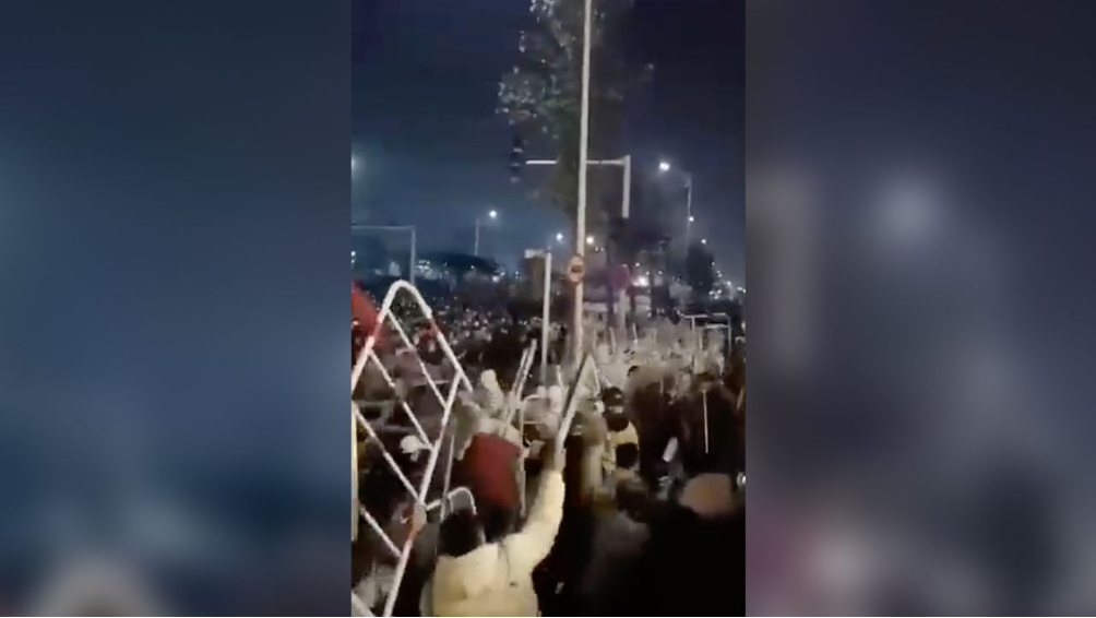
As for the challenges, I can talk about some that our group encountered when we were working on the exercise in the workshop session. The first one was how maps can deal with silences. In the case of the worker protests at Foxconn, the Chinese government tried to censor media coverage and the dissemination of videos on social media. On the other side of the globe, Apple, which uses the components manufactured by the workers in their devices, refused to comment on the protests. Trying to create visibility, maps somewhat rely on it for their empirical materials. In the face of silences and corporate secrecy the maps risk perpetuating or even creating new invisibilities. “Historicity” was a second challenge. As two-dimensional representations/interventions, maps freeze a particular moment of time. A quote by Tommaso Venturini (2010, p. 268) captures this nicely: When we create maps “we contribute to the solidification of some portions of social magma”.
Mapping as a method: what kind of skills and collaborations would be necessary for it to work?
I think one crucial condition for mapping is the transdisciplinarity of those doing the mapping. By this I mean not only that the cartographers come from different disciplines – this was a strength of the DigiGov Winter School from which I really profited – but also different ways of engaging with insights: researchers, artists, activists. The second condition, diversity, also speaks to this. Kate Crawford (2021, p. 10) writes that “maps, at their best, offer us a compendium of open pathways – shared ways of knowing – that can be mixed and combined to make new interconnections”. In this sense, different perspectives need to come together so that something truly new and insightful can emerge. This entails that we are reflexive of our own positionality when drawing maps but also of the limits of maps as always partial representations/interventions. Care, I would say, is another condition. How do we care about what we map and how can we avoid obfuscating the experiences of those whose realities we map? In this sense, we should also continuously ask how our maps can stimulate and bring about emancipatory transformations, more “liveable worlds” to use Donna Haraway’s term.
How could such maps be “translated” into social change?
From a Global North perspective, I think that these kinds of maps can create awareness about how our everyday actions are entangled with global networks of the exploitation of human labour and the earthly resources. Visibility is not all bad, it depends on what follows from it. While I don’t think that more reflexive consumer choices can change much, maybe we can use maps to forge new “geographies of responsibility”, as Madeleine Akrich (1992) calls it. If the supply chains of our digital technologies span the globe, why do we still not have global institutions for governing them, to hold those accountable whose economic interests drive the exploitation of humans and the earth and who massively profit from these chains?
Beyond this limited perspective, the maps can maybe produce new global networks of solidarity based on structural proximity. If the workers become aware that they are part of the same network from which only a few harvest profits, this could open up new pathways for organising and resisting within these networks. Maybe this would come close to the “South-South solidarity networks” as spaces for actual changes from below that Noopur (2021, p. 30) mentions. And because, as he explained in the session, Vladan also sought to emphasise the exploitation of earthly resources (which he calls “new extractivism” in another project), maybe this can help to bring together the global “ecological class” (Latour & Schultz, 2022) as a more-than-human political collective that is able to take up the struggles for the world that sustains the life of all earthly beings.
Concluding remarks:
In conclusion: how can maps and mapping methods help us to attend to the invisibilities of inequalities related to digital practices that were on the agenda of the second day of this year’s DigiGov Winter School? Maps allow us to think about the global interrelations that make our most mundane digital practices possible and to think within the same frame of reference the exploitation of human labour and earthly resources, the entanglements of nature, society and technology. In this sense, maps are a tool to think further within transdisciplinary teams with a diversity of situated perspectives because they invite us to consider what often remains hidden from us. At the same time, harking back to the critique Noopur Raval developed in her talk, it is necessary to be critical of the shortcomings of maps, the colonial heritage of mapping techniques and their epistemological underpinnings, such as privileging spatiality over temporality and solidifying a particular moment in time.
One crucial question then is whether and how maps can serve to make interventions in the global networks of digital capitalism without – despite all good intentions – creating new invisibilities and silencing the perspectives of workers in the Global South. Thinking together with Noopur Raval, Monika Halkort, Vladan Joler and Felix Stalder we suggest that by forging new geographies of responsibility and helping to bring together the global ecological class, maps could inspire new pathways for organising and resisting within the networks that maps render visible.
References
Akrich, M. (1992). The De-Scription of Technical Objects. In W. E. Bijker & J. Law (Eds.), Shaping Technology/Building Society. Studies in Sociotechnological Change. (pp. 205–224). MIT Press.
Crawford, K. (2021). Atlas of AI. Power, Politics, and the Planetary Costs of Artificial Intelligence. Yale University Press.
Gan, N., & Liu, J. (2022, November 24). Foxconn offers to pay workers to leave world’s largest iPhone factory after violent protests | CNN Business. CNN. https://www.cnn.com/2022/11/24/business/foxconn-offer-protests-china-covid-intl-hnk/index.html
Gray, M. L., & Suri, S. (2019). Ghost work: How to stop Silicon Valley from building a new global underclass. Houghton Mifflin Harcourt.
Holt, J., & Vonderau, P. (2015). “Where the Internet Lives”. Data Centers as Cloud Infrastructures. In L. Parks & N. Starosielski (Eds.), Signal Traffic. Critical Studies of Media Infrastructures (pp. 71–93). University of Illinois Press.
Latour, B., & Schultz, N. (2022). On the Emergence of an Ecological Class. A Memo. Polity Press.
Mattern, S. (2016). Cloud and Field. Places Journal. https://doi.org/10.22269/160802
Raval, N. (2021). Interrupting invisibility in a global world. Interactions, 28(4), 27–31. https://doi.org/10.1145/3469257
Venturini, T. (2010). Diving in magma: How to explore controversies with actor-network theory. Public Understanding of Science, 19(3), 258–273.
Carsten Horn is a researcher for the research project “Innovation Residues” at the Department of Science and Technology Studies at the University of Vienna. His research interests are situated at the intersections of STS, sociology and philosophy.
Katja Mayer is a sociologist at the Department of Science and Technology Studies at the University of Vienna. Her research focuses on the relationship between social scientific methods and their publics, with particular emphasis on Computational Social Science, Big Data, and Machine Learning. In addition to her academic work, she also serves as a Senior Scientist at the Center for Social Innovation, where she conducts research on innovation and research policy issues.